Budhi Gandaki Hydropower project
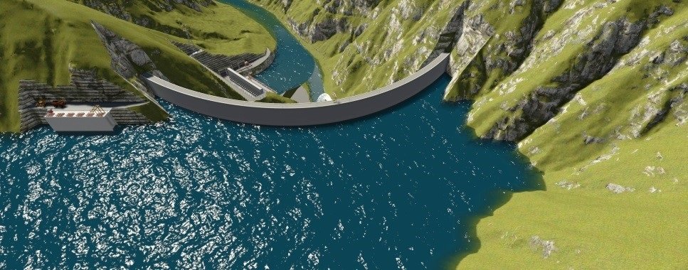
Budhi gandaki project is one of the biggest and Nepal’s national pride project.The Budhi Gandaki Hydroelectric Project is a storage type of project located between boundaryof Gorkha and Dhading district on the Budhi Gandaki River in Central/ Western Developmentregion of Nepal. The prefeasibility study of Budhi Gandaki Hydropower Project found theproject with the option of 600 MW with FSL 520 masl as the most promising and recommended for the project development. The past studies concluded that the project is attractive due to its high energy potential, large storage volume, its’ location and access in Central Nepal near to the main load center.
The Budhi Gandaki Hydropower Project is located on the Budhi Gandaki River, approximately 2
km from its confluence with Trishuli River at Benighat. Benighat can be accessed by the Prithivi
Highway linking Kathmandu and Pokhara about 80 km from Kathmandu. The Project area lies in
the districts of Gorkha and Dhading of Western and Central Development Region of Nepal.
Present status and analysis
The Government of Nepal carried out the prefeasibility study of the project in 1984. The study
covers power simulation and evaluation of alternative project sites, geotechnics, geology,
geophysics, seismicity, hydrology, socio -economic impact. The selected scheme in the
prefeasibility study consists of a 225 m high rockfill dam, reservoir covering an area of 49.8 km2
at the full supply level (FSL) of 520 masl and having gross storage volume of 3,320 X 106
m3 atFSL, a spillway of discharge capacity of 12,827 m3
/s in the right abutment, a headrace tunnel of276 m length, and underground powerhouse with and installed capacity of 600 MW and average
annual energy generation of 2495 GWH , a tailrace tunnel of 1.1 km length with a surge
chamber. The station houses four Francis turbines with a rated net head of 185 m and a rated
discharge of 107.5 m3/s.
NEA has carried out additional studies in fiscal year 2010/11 including identification of
alternative locations of the project facilities/structures with a view to achieve optimum utilization
of hydropower power potential of the project site. An alternative location of tailrace near Fisling
around 10 km downstream of the Benighat in Trisuli river has been identified, which would
result in additional head gain of about 35 m yielding additional energy generation upto 700
GWh. About 7 km of additional tunnel needs to be constructed for this option. Survey control
points with permanent concrete blocks (monuments) has been established around the reservoir
periphery at around 525 masl to establish reference boundary for household counting and further.

reservoir mapping. Altogether 62 ssurvey monuments have been established near major villages
and settlement areas. Additionally, household counting has been completed upto 540 masl,
NEA has established three river gauge stations in Budhi Gandaki river at various locations. One
is located at Ankhu River, a tributary of Budhigangaki (Established by Department of
Hydrology and Meteorology, DHM/ GoN and rehabilated by NEA), one at Budhi Gandaki River
downstream of proposed dam site and the other at Trisuli River at the tailrace of the proposed
underground powerhouse. NEA intends to hire services of consultant by the end of fiscal year
2010/11 for LiDAR mapping of the Budhi Gandaki project area covering reservoir and its
periphery, and the procurement process is underway.
You may also like

New Dem File Of Nepal
